RU/CreateWater: Difference between revisions
Jump to navigation
Jump to search
(Created page with "__NOTOC__ {{Server client function}} Creates an area of water. The largest possible size of a water area is 5996×5996. Also be aware that the function will change all...") |
(No difference)
|
Revision as of 17:19, 28 July 2011
Creates an area of water.
The largest possible size of a water area is 5996×5996. Also be aware that the function will change all x and y coordinates you specify into even integer numbers if necessary: this is because of a limitation of San Andreas.
Syntax
water createWater ( float x1, float y1, float z1, float x2, float y2, float z2, float x3, float y3, float z3 [, float x4, float y4, float z4 ] [, bool bShallow = false ] )
Required Arguments
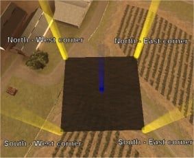
For creating a water quadrant:
- x1, y1, z1: position of bottom left (south-west) corner.
- x2, y2, z2: position of bottom right (south-east) corner.
- x3, y3, z3: position of top left (north-west) corner.
- x4, y4, z4: position of top right (north-east) corner.
For creating a water triangle:
- x1, y1, z1: position of bottom/top left corner.
- x2, y2, z2: position of bottom/top right corner.
- x3, y3, z3: position of top/bottom corner.
Optional Arguments
- bShallow: ask arc_
Returns
Returns a water element if successful, false otherwise. The water element can be repositioned with setElementPosition and destroyed with destroyElement.
Example
Click to collapse [-]
ClientExample code for creating a water area to cover the entire San Andreas Map (flood the cities). Also, setWaterLevel is used to raise the existing rivers and lakes.
-- Setting water properties.
height = 40
SizeVal = 2998
-- Defining variables.
southWest_X = -SizeVal
southWest_Y = -SizeVal
southEast_X = SizeVal
southEast_Y = -SizeVal
northWest_X = -SizeVal
northWest_Y = SizeVal
northEast_X = SizeVal
northEast_Y = SizeVal

-- OnClientResourceStart function that creates the water.
function thaResourceStarting( )
    water = createWater ( southWest_X, southWest_Y, height, southEast_X, southEast_Y, height, northWest_X, northWest_Y, height, northEast_X, northEast_Y, height )
    setWaterLevel ( height )
end
addEventHandler("onClientResourceStart", getResourceRootElement(getThisResource()), thaResourceStarting)
See Also
- getWaterLevel
- isWaterDrawnLast
- setWaterDrawnLast
- Shared
- createWater
- getWaterColor
- getWaterVertexPosition
- getWaveHeight
- resetWaterColor
- resetWaterLevel
- setWaterColor
- setWaterLevel
- setWaterVertexPosition
- setWaveHeight
